Geometry ��(du��)��\��_.Net�̳�
���]�����hASP.NET DataGrid�ؼ��еġ��������С����������f(shu��)����DataGrid���������У�ASP.NET�_�l(f��)�Ĵ�ţ���Dino Esposito�����ġ���(g��u)��WEB��Q����--��(y��ng)��ASP.NET��ADO.NET��һ�����ṩ�˺����σ�λ��Ƶķ���������Dino�ּ���Щ���ܣ����Ⱦ���&rd
����ArcEngine Geometry��(k��)���x�˻����ΈD�ε�ʸ�����_(d��)��ʽ��피�(j��)�ĎΈD����Points��Multipoints��Polylines��Polygons�� Multipatches��Geodatabase���L�Dϵ�y(t��ng)ʹ���@Щ�ΈD��(l��i)���x�������N�Π�������͈D�Σ��ṩ�˾��D�εIJ��������͵؈D��̖(h��o)ϵ�y(t��ng)��̖(h��o)��������(sh��)��(j��)��;����
����Geometry��(k��)�Ўׂ�(g��)����ͽӿژ�(g��u)����Geometry��(du��)��Ļ�����ܡ�
����GeometryEnvironment
����GeometryEnvironment�ṩ�ˏIJ�ͬ��ݔ�롢�O(sh��)�û�@ȡȫ��׃����(l��i)��(chu��ng)���ΈD�εķ������Ա����geometry�������О顣GeometryEnvironment��(du��)����һ��(g��)������(du��)��
�������õă�(n��i)�ݣ� public IPolyline TestGeometryEnvironment() public IPolyline TestGeometryEnvironment()   { { ISpatialReferenceFactory spatialReferenceFactory = new SpatialReferenceEnvironmentClass(); //Create a projected coordinate system and define its domain, resolution, and x,y tolerance. ISpatialReferenceResolution spatialReferenceResolution = spatialReferenceFactory.CreateProjectedCoordinateSystem((int)esriSRProjCSType.esriSRProjCS_NAD1983UTM_11N) as ISpatialReferenceResolution; spatialReferenceResolution.ConstructFromHorizon(); ISpatialReferenceTolerance spatialReferenceTolerance = spatialReferenceResolution as ISpatialReferenceTolerance; spatialReferenceTolerance.SetDefaultXYTolerance(); ISpatialReference spatialReference = spatialReferenceResolution as ISpatialReference; //Create an array of WKSPoint structures starting in the middle of the x,y domain of the //projected coordinate system. double xMin; double xMax; double yMin; double yMax; spatialReference.GetDomain(out xMin, out xMax, out yMin, out yMax); double xFactor = (xMin xMax) * 0.5; double yFactor = (yMin yMax) * 0.5; WKSPoint[] wksPoints = new WKSPoint[10]; for (int i = 0; i < wksPoints.Length; i ) ISpatialReferenceFactory spatialReferenceFactory = new SpatialReferenceEnvironmentClass(); //Create a projected coordinate system and define its domain, resolution, and x,y tolerance. ISpatialReferenceResolution spatialReferenceResolution = spatialReferenceFactory.CreateProjectedCoordinateSystem((int)esriSRProjCSType.esriSRProjCS_NAD1983UTM_11N) as ISpatialReferenceResolution; spatialReferenceResolution.ConstructFromHorizon(); ISpatialReferenceTolerance spatialReferenceTolerance = spatialReferenceResolution as ISpatialReferenceTolerance; spatialReferenceTolerance.SetDefaultXYTolerance(); ISpatialReference spatialReference = spatialReferenceResolution as ISpatialReference; //Create an array of WKSPoint structures starting in the middle of the x,y domain of the //projected coordinate system. double xMin; double xMax; double yMin; double yMax; spatialReference.GetDomain(out xMin, out xMax, out yMin, out yMax); double xFactor = (xMin xMax) * 0.5; double yFactor = (yMin yMax) * 0.5; WKSPoint[] wksPoints = new WKSPoint[10]; for (int i = 0; i < wksPoints.Length; i )  { wksPoints[i].X = xFactor i; wksPoints[i].Y = yFactor i; { wksPoints[i].X = xFactor i; wksPoints[i].Y = yFactor i; } IPointCollection4 pointCollection = new PolylineClass(); IGeometryBridge2 geometryBridge = new GeometryEnvironmentClass(); geometryBridge.AddWKSPoints(pointCollection, ref wksPoints); IPolyline polyline = pointCollection as IPolyline; polyline.SpatialReference = spatialReference; return polyline; } IPointCollection4 pointCollection = new PolylineClass(); IGeometryBridge2 geometryBridge = new GeometryEnvironmentClass(); geometryBridge.AddWKSPoints(pointCollection, ref wksPoints); IPolyline polyline = pointCollection as IPolyline; polyline.SpatialReference = spatialReference; return polyline; } } |
����new GeometryEnvironmentClass�H�H�DŽ�(chu��ng)����һ��(g��)ָ���Ѵ��ڵ�GeometryEnvironmentClass�����á�ע�� IGeometryBridge2�ӿڵ�ʹ�ã�addWKSPoints������WKSPoint���S�c(di��n)���ӵ�PointCollection�У����ژ�(g��u)�� path��ring��polyline��polygon�����������c(di��n)��Multipoint��TriangleFan��TriangleStrip���� Geometry��(k��)�У�����IGeometryBridge2߀��IGeometryBridge�ӿڣ������^����ǰ�ߣ�������һЩ�����ܣ������c(di��n)�������c(di��n)�������c(di��n)���ֶεȣ���
����GeometryBag
����GeometryBag��֧��IGeometry�ӿڵĎΌ�(du��)�����õļ��ϣ��κΎΌ�(du��)����ͨ�^IGeometryCollection�ӿ����ӵ� GeometryBag�У�������ʹ����?f��)�����ĕr(sh��)����Ҫע�ⲻͬ��͵Ď���Ϳ��ܕ�(hu��)��������ݵ���r������GeometryBag�����ӎΌ�(du��)��ĕr(sh��)��GeometryBag��(du��)����Ҫָ�����g���������ӵ����еĎΌ�(du��)������к�GeometryBag��(du��)��һ�ӵĿ��g������
| �������õă�(n��i)�ݣ�private IPolygon GeometryBag_Example(IFeatureClass featureClass){ //Check input objects. if (featureClass == null) { return null; } IGeoDataset geoDataset = featureClass as IGeoDataset; ISpatialFilter queryFilter = new SpatialFilterClass(); //Set the properties of the spatial filter here. IGeometry geometryBag = new GeometryBagClass(); //Define the spatial reference of the bag before adding geometries to it. geometryBag.SpatialReference = geoDataset.SpatialReference; //Use a nonrecycling cursor so each returned geometry is a separate object. IFeatureCursor featureCursor = featureClass.Search(queryFilter, false); IGeometryCollection geometryCollection = geometryBag as IGeometryCollection; IFeature currentFeature = featureCursor.NextFeature(); while (currentFeature != null) { //Add a reference to this feature's geometry into the bag. //You don't specify the before or after geometry (missing), //so the currentFeature.Shape IGeometry is added to the end of the geometryCollection. object missing = Type.Missing; geometryCollection.AddGeometry(currentFeature.Shape, ref missing, ref missing); currentFeature = featureCursor.NextFeature(); } // Create the polygon that will be the union of the features returned from the search cursor. // The spatial reference of this feature does not need to be set ahead of time. The // ConstructUnion method defines the constructed polygon's spatial reference to be the same as // the input geometry bag. ITopologicalOperator unionedPolygon = new PolygonClass(); unionedPolygon.ConstructUnion(geometryBag as IEnumGeometry); return unionedPolygon as IPolygon;} |
����Points
����һ��(g��)�c(di��n)����X��Y����(bi��o)��ͬ�r(sh��)��������M��Zֵ��ID���ԁ�(l��i)�U(ku��)չ�c(di��n)�Ĺ��ܡ�
����Multipoints
�����c(di��n)�ļ��ϣ����c(di��n)�M��Multipoint����ͣ�ʹ��multipoint��(du��)��(sh��)�F(xi��n)�˵�IPointCollection�ӿڿ����L�����е��c(di��n)Ԫ�أ��@Щ�c(di��n)ͬ�ӿ��ԓ���M��Zֵ��ID���ԁ�(l��i)�@�ø���ĵ������g��(n��i)����
�����������eһ��(g��)���ӣ�ͨ�^һ��(g��)��֪��polyline��(l��i)���xһ��(g��)�µ�multipart polyline��
| �������õă�(n��i)�ݣ�public IPolyline ConstructMultiPartPolyline(IPolyline inputPolyline){ IGeometry outGeometry = new PolylineClass(); //Always associate new, top-level geometries with an appropriate spatial reference. outGeometry.SpatialReference = inputPolyline.SpatialReference; IGeometryCollection geometryCollection = outGeometry as IGeometryCollection; ISegmentCollection segmentCollection = inputPolyline as ISegmentCollection; //Iterate over existing polyline segments using a segment enumerator. IEnumSegment segments = segmentCollection.EnumSegments; ISegment currentSegment; int partIndex = 0;; int segmentIndex = 0;; segments.Next(out currentSegment,ref partIndex, ref segmentIndex); while(currentSegment != null) { ILine normal = new LineClass(); //Geometry methods with _Query_ in their name expect to modify existing geometries. //In this case, the QueryNormal method modifies an existing line //segment (normal) to be the normal vector to //currentSegment at the specified location along currentSegment. currentSegment.QueryNormal(esriSegmentExtension.esriNoExtension, 0.5, true, currentSegment.Length / 3, normal); //Since each normal vector is not connected to others, create a new path for each one. ISegmentCollection newPath = new PathClass(); object missing = Type.Missing; newPath.AddSegment(normal as ISegment, ref missing, ref missing); //The spatial reference associated with geometryCollection will be assigned to all incoming paths and segments. geometryCollection.AddGeometry(newPath as IGeometry, ref missing, ref missing); segments.Next(out currentSegment,ref partIndex, ref segmentIndex); } //The geometryCollection now contains the new, multipart polyline. return geometryCollection as IPolyline;} |
����ISegment�ӿڵ�QueryNormal�����Á�(l��i)�ڻ����ϵ�ijһ�c(di��n)����ԓ���εķ�����ָ�����L(zh��ng)�ȣ��@�Ӿ��������µ�segment�����Ҷ���(g��)path���ӵ�geometryCollection�У���IPolyline����ʽ���ء�
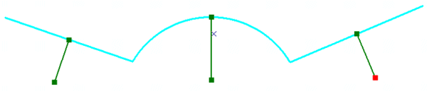
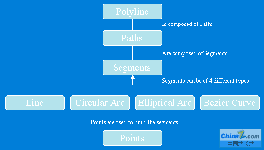
����Polylines
����Polylines������path�M�ɵļ��ϣ����ԓ���M��Z��ID����ֵ��Polyline��(du��)���IPointCollection�ӿڰ��������й�(ji��)�c(di��n)�ď�(f��)�ƣ�IGeometryCollection�ӿڿ��ԫ@ȡpolyline��paths��ISegmentCollection�ӿڿ��ԫ@ȡ polyline��segments��
����Polyline�Y(ji��)��(g��u)�D
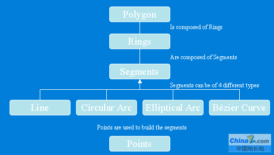
����Polygons
����Polygon��һϵ��rings�M�ɵļ��ϣ����ԓ���M��Z��ID����ֵ��ÿһ��(g��)ring��һ��(g��)�����(g��)segment�M�ɣ�Polygon��ring��(du��)���IPointCollection�ӿڰ��������й�(ji��)�c(di��n)�ď�(f��)�ƣ�IGeometryCollection�ӿڿ��ԫ@ȡpolygon��rings�� ISegmentCollection�ӿڿ��ԫ@ȡpolygon��segments��
����Polygon�Y(ji��)��(g��u)�D
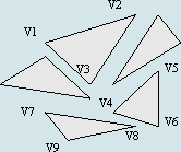
����Multipatch
����Multipatch��������3D������ͣ���һϵ�е�ʸ�������Θ�(g��u)�ɣ�������е�part��һ��(g��)ring����ô������Ƿ��]�ģ���һ��(g��)��(ji��)�c(di��n)�����һ��(g��)��(ji��)�c(di��n)��ͬ������ÿ��(g��)part��������(ji��)�c(di��n)�����dz���Ҫ��Inner Rings��Outer Rings֮�����(g��)����patch��һϵ��rings����ɵ�һ��(g��)ring�_ʼ��
������9.0�Ժ���_�l(f��)���У�ʹ��IGeneralMultiPatchCreator��(chu��ng)���µ�Multipatch��IGeometryMaterial�M(j��n)�в��|(zh��)�N�D��
| �������õă�(n��i)�ݣ�public IMultiPatch CreateMultipatch(){ //Prepare the geometry material list. IGeometryMaterial texture = new GeometryMaterialClass(); texture.TextureImage = "C:\\Temp\\MyImage.bmp"; IGeometryMaterialList materialList = new GeometryMaterialListClass(); materialList.AddMaterial(texture); //Create the multipatch. IGeneralMultiPatchCreator multiPatchCreator = new GeneralMultiPatchCreatorClass(); multiPatchCreator.Init(4, 1, false, false, false, 4, materialList); //Set up part. //Could also use a Ring or a TriangleFan. multiPatchCreator.SetPatchType(0, esriPatchType.esriPatchTypeTriangleStrip); multiPatchCreator.SetMaterialIndex(0, 0); multiPatchCreator.SetPatchPointIndex(0, 0); multiPatchCreator.SetPatchTexturePointIndex(0, 0); //Set real-world points. WKSPointZ upperLeft = new WKSPointZ(); WKSPointZ lowerLeft = new WKSPointZ(); WKSPointZ upperRight = new WKSPointZ(); WKSPointZ lowerRight = new WKSPointZ(); upperLeft.X = 0; upperLeft.Y = 0; upperLeft.Z = 0; upperRight.X = 300; upperRight.Y = 0; upperRight.Z = 0; lowerLeft.X = 0; lowerLeft.Y = 0; lowerLeft.Z = -100; lowerRight.X = 300; lowerRight.Y = 1; lowerRight.Z = -100; multiPatchCreator.SetWKSPointZ(0, ref upperRight); multiPatchCreator.SetWKSPointZ(1, ref lowerRight); multiPatchCreator.SetWKSPointZ(2, ref upperLeft); multiPatchCreator.SetWKSPointZ(3, ref lowerLeft); //Set texture points. //Set the texture coordinates for a panel. WKSPoint textureUpperLeft = new WKSPoint(); WKSPoint textureLowerLeft = new WKSPoint(); WKSPoint textureUpperRight = new WKSPoint(); WKSPoint textureLowerRight = new WKSPoint(); textureUpperLeft.X = 0; textureUpperLeft.Y = 0; textureUpperRight.X = 1; textureUpperRight.Y = 0; textureLowerLeft.X = 0; textureLowerLeft.Y = 1; textureLowerRight.X = 1; textureLowerRight.Y = 1; multiPatchCreator.SetTextureWKSPoint(0, ref textureUpperRight); multiPatchCreator.SetTextureWKSPoint(1, ref textureLowerRight); multiPatchCreator.SetTextureWKSPoint(2, ref textureUpperLeft); multiPatchCreator.SetTextureWKSPoint(3, ref textureLowerLeft); IMultiPatch multiPatch = multiPatchCreator.CreateMultiPatch() as IMultiPatch; return multiPatch;} |
������AJAX��(sh��)�F(xi��n)web�(y��)���м�(j��)(li��n)�ˆε��O(sh��)Ӌ(j��)�������˴�{��ļ�(j��)(li��n)�ˆΣ���Ҳ���TŪ��һ�ѣ��ٺ٣�����һ�c(di��n)�r(sh��)�g���˂�(g��)��(j��)(li��n)�ˆ��N�ρ�(l��i)������������ֻҪ���x��ɆT������Q�͕�(hu��)�Ԅ�(d��ng)�@ʾ�ɆT���Q�� ������eclipse�н�һ��(g��)�(xi��ng)Ŀ�����Q����
- asp.net��εõ�GRIDVIEW��ij��ij��ֵ�ķ���
- .net SMTP�l(f��)��Email��(sh��)��(�Ɏ�����)
- js��(sh��)�F(xi��n)�V��Ư��Ч����С����
- asp.net Repeater ��(sh��)��(j��)�����ľ��w��(sh��)�F(xi��n)
- Asp.Net �o(w��)ˢ���ļ��ς����@ʾ�M(j��n)�ȗl�Č�(sh��)�F(xi��n)������˼·
- Asp.net�@ȡ�͑���IP��Ҋ���a���ڵĂ���IP���}̽ӑ
- VS2010 ˮ����(b��o)����ʹ�÷���
- ASP.NET�в���SQL��(sh��)��(j��)��(k��)(�B���ַ��������ü��@ȡ)
- asp.net�(y��)��?zh��n)�ֵ�y(c��)ԇ��(sh��)�����a
- DataGridView - DataGridViewCheckBoxCell��ʹ�ý�B
- asp.net��javascript������(ֱ��������g������)
- ����+�惦(ch��)�^�̌�(sh��)�F(xi��n)���(y��)ʾ�����a
.Net�̳�Rssӆ����̳̽�����
.Net�̳����]
- ASP.NET�������ֽ̳�(14)
- ���xVS2008�в鿴.NETԴ�a���O(sh��)�÷���
- ����Asp.net��(d��ng)�B(t��i)�����(y��)��ؼ����k��
- ����̓�M���C(j��)����Asp.net��(sh��)�F(xi��n)Urlrewrite
- Asp.Netʹ��POST�����(ji��n)�εČ�(sh��)�F(xi��n)
- Asp.net FMS �_�l(f��)ҕ�l�W(w��ng)վ
- ����DataList��HyperLink��(sh��)��(j��)������朽ӌ���
- ����������TASP.NET��(sh��)��(j��)��(k��)����
- Asp.net�е�mail�İl(f��)��
- ����.Net���A(ch��)��C#�Ќ�(du��)DatagridView���ֳ��ò���
- ���P(gu��n)朽ӣ�
- �̳��f(shu��)����
.Net�̳�-Geometry ��(du��)��\��
 ��
��